Continental-Scale Building Detection from High Resolution Satellite Imagery 제2부
1 Introduction
Building footprints are useful for a range of important applications, from mapping, population estimation and urban planning to humanitarian response and environmental science.
건물 발자국은 매핑, 인구 추정 및 도시 계획에서 인도주의적 대응 및 환경 과학에 이르기까지 다양한 중요한 응용 분야에 유용합니다.
In developing regions this information can be particularly valuable, for instance in areas with infrequent censuses, or with a high prevalence of informal settlements, or where there is rapid change, such as in emerging mega-cities.
infrequent 드문 censuses 인구조사 high prevalence 널리 퍼진 settlements 정착지 emerging 최근에 나타난
개발 도상 지역에서는 이러한 정보가 특히 유용할 수 있다. 예를 들어 인구 조사가 자주 이루어지지 않거나 비공식 정착이 많이 이루어지는 지역이나 신흥 거대 도시와 같이 급격한 변화가 있는 지역에서 말이다.
Although the detection of buildings in developing regions can be technically challenging, it has the potential to address large information gaps with respect to current knowledge.
개발 도상국에서 건물을 감지하는 것은 기술적으로 어려울 수 있지만 현재 지식과 관련하여 큰 정보 격차를 해결할 가능성이 있습니다.
In this work, we describe the development of a detection pipeline for identifying building footprints across the continent of Africa from satellite imagery of 50 cm resolution.
이 작업에서 우리는 50cm 해상도의 위성 이미지에서 아프리카 대륙 전역의 건물 발자국을 식별하기 위한 탐지 파이프라인의 개발을 설명합니다.
The land surface of Africa is about 20% of the Earth’s total and has a wide diversity of terrain and building types, meaning that this is a broad and challenging problem.
아프리카의 육지 표면은 지구 전체의 약 20%이며 지형과 건물 유형이 매우 다양하므로 이는 광범위하고 어려운 문제입니다.
Challenges include the range of geological or vegetation features which can be confused with built structures, settlements with many contiguous buildings not having clear delineations, and areas characterised by small buildings, which can appear only a few pixels wide at this resolution.
delineation 묘사 contiguous 인접한
해결해야 할 과제에는 건축 구조물과 혼동될 수 있는 지질학적 또는 식생 특성의 범위, 명확한 묘사가 없는 인접한 많은 건물이 있는 정착지, 이 해상도에서 너비가 몇 픽셀에 불과할 수 있는 작은 건물이 특징인 영역이 포함됩니다.
In rural or desert areas, buildings constructed with natural materials can visually blend in to the surrounding area. Figures 1 and 3 show some examples.
시골이나 사막 지역에서는 자연 소재로 지어진 건물이 주변 지역과 시각적으로 조화를 이룰 수 있습니다. 그림 1과 3은 몇 가지 예를 보여줍니다.
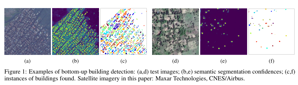
Figure 1: Examples of bottom-up building detection: (a,d) test images; (b,e) semantic segmentation confidences; (c,f) instances of buildings found. Satellite imagery in this paper: Maxar Technologies, CNES/Airbus.
그림 1: 상향식 건물 감지의 예: (a,d) 테스트 이미지; (b,e) 의미론적 분할 신뢰도; (c,f) 건물의 사례가 발견되었습니다. 이 문서의 위성 이미지: Maxar Technologies, CNES/Airbus.
Progress in deep learning methods with remote sensing imagery has created new possibilities for working at this scale, and recent work on building detection from high resolution satellite imagery has shown remarkable improvements in precision and recall, which we review briefly in Section 2.
briefly 간략히 possibilities 가능성
원격 감지 이미지를 사용한 딥 러닝 방법의 발전은 이 규모에서 작업할 수 있는 새로운 가능성을 창출했으며 고해상도 위성 이미지에서 건물 감지에 대한 최근 작업은 정밀도와 재현율에서 현저한 개선을 보여주었으며 이에 대해서는 섹션 2에서 간략하게 검토합니다.
Common to much of this work is the U-Net architecture [1], an encoder-decoder model for semantic segmentation.
이 작업의 대부분에 공통적인 것은 의미론적 분할을 위한 인코더-디코더 모델인 U-Net 아키텍처[1]입니다.
Rather than learning to identify building instances with an end-to-end model, the idea in this type of ‘bottom-up’ segmentation is to classify each pixel of an aerial image as building or non-building, and then to find connected components at some confidence score threshold.
aerial image 항공 이미지
종단 간 모델로 건물 인스턴스를 식별하는 방법을 배우는 대신, 이러한 유형의 '상향식'세분화의 아이디어는 항공 이미지의 각 픽셀을 건물 또는 비건물로 분류한 다음 일부 신뢰도 점수 임계값에서 연결된 구성 요소를 찾는 것입니다.
Illustrations of our model operating in this way are shown in Figure 1.
이러한 방식으로 작동하는 모델의 그림은 그림 1에 나와 있습니다.
Existing studies have tended to be limited to particular cities or countries, however, leaving an open question as to how well such methods generalise to wider areas, particularly in developing regions..
그러나 기존 연구는 특정 도시나 국가에 국한되는 경향이 있어 그러한 방법이 특히 개발 도상국에서 더 넓은 지역에 얼마나 잘 일반화되는지에 대한 열린 질문을 남겼습니다.
Figure 1: Examples of bottom-up building detection: (a,d) test images; (b,e) semantic segmentation confidences; (c,f) instances of buildings found. Satellite imagery in this paper: Maxar Technologies, CNES/Airbus.
그림 1: 상향식 건물 감지의 예: (a,d) 테스트 이미지; (b,e) 의미론적 분할 신뢰도; (c,f) 건물의 사례가 발견되었습니다. 이 문서의 위성 이미지: Maxar Technologies, CNES/Airbus.
We begin by describing training and evaluation datasets compiled for this work in Section 3, including weakly labelled and unlabelled image data for pre-training and self-training respectively.
사전 훈련 및 자체 훈련에 대해 각각 레이블이 약한 이미지 데이터와 레이블이 지정되지 않은 이미지 데이터를 포함하여 섹션 3에서 이 작업을 위해 컴파일된 훈련 및 평가 데이터 세트를 설명하는 것으로 시작합니다.
We then describe a number of methods tested to improve building detection performance, in the following categories:
그런 다음 다음 범주에서 건물 감지 성능을 개선하기 위해 테스트된 여러 방법을 설명합니다.
• Choices of architecture, concerning different encoders and decoders (Section 4).
• 다양한 인코더 및 디코더와 관련된 아키텍처 선택(섹션 4).
• Loss functions which are more appropriate for building segmentation than generic segmentation choices (Section 5).
• 일반 분할 선택보다 분할 구축에 더 적합한 손실 함수(섹션 5).
• Regularization, including mixup and other augmentations (Section 6).
• 혼합 및 기타 보강을 포함한 정규화(섹션 6).
• Pre-training (Section 7).
• 사전 교육(섹션 7).
• Self-training methods for improving building detection performance using additional unlabelled data (Section 8).
• 레이블이 지정되지 않은 추가 데이터를 사용하여 건물 감지 성능을 개선하기 위한 자체 교육 방법(섹션 8).
• Pre-processing methods for preparing the input image and labels, including morphological adjustments (Section 9).
morphological 형태상의
• 형태학적 조정을 포함하는 입력 영상 및 레이블을 준비하기 위한 사전 처리 방법(섹션 9).
• Post-processing methods for converting semantic segmentation predictions into predicted instances (Section 10).
convert 변환하다
• 의미론적 분할 예측을 예측된 인스턴스로 변환하기 위한 후처리 방법(섹션 10).
We report experimental results in Section 11, including ablation studies to determine the effectiveness of different methods, and evaluation of the accuracy and consistency of the resulting building detection pipeline in different contexts.
consistency 일관성
우리는 섹션 11에서 실험 결과를 보고합니다. 여기에는 다양한 방법의 효율성을 결정하기 위한 절제 연구와 다양한 상황에서 결과 건물 감지 파이프라인의 정확성과 일관성에 대한 평가가 포함됩니다.
In summary, the main contributions of this work are: (1) we provide the first experimental results, to our knowledge, on the training and evaluation of building detection models on high resolution aerial imagery at a continental scale,
요약하면, 이 작업의 주요 기여는 다음과 같습니다. (1) 우리는 대륙 규모의 고해상도 항공 이미지에 대한 건물 감지 모델의 교육 및 평가에 대한 우리가 아는 한 첫 번째 실험 결과를 제공합니다.
(2) we propose a number of specific methods for improving building detection performance using the U-Net model, including mixup, self-training, distance weighting with Gaussian convolutions, and residual decoder blocks, and
(2) U-Net 모델을 사용하여 건물 감지 성능을 개선하기 위한 여러 가지 특정 방법을 제안합니다. 여기에는 mixup, self-training, Gaussian convolution을 사용한 거리 가중치, 잔여 디코더 블록이 포함됩니다.
(3) the resulting pipeline was used to generate an open dataset of 516M building footprints across Africa, available at https://sites.research.google/open-buildings.
(3) 결과 파이프라인은 https://sites.research.google/open-buildings에서 사용할 수 있는 아프리카 전역의 5억 1600만 건물 발자국의 공개 데이터 세트를 생성하는 데 사용되었습니다.