Improving urban GPS accuracy for your app
📗 단어 정리 📘
OBS BUILD
| 영어 | 한글 |
|---|---|
| dense | 밀집한 |
| rideshare | 차량공유 |
| embark | 착수하다 |
| ambitious | 야심 |
| pedestrian | 보행자, 보행자용의 |
| ecosystem | 생태계 |
| milestone | 중요한 단계, 이정표 |
| advancement | 발전, 진보 |
At Android, we want to make it as easy as possible for developers to create the most helpful apps for their users.
안드로이드에서, 우리는 개발자들이 앱 사용자들에게 가장 유용한 앱을 쉽게 만들기를 원합니다.
That’s why we aim to provide the best location experience with our APIs like the Fused Location Provider API (FLP).
이것이 FLP와 같은 우리의 API와 함께 최고의 위치 경험을 제공하는 것을 목표로하는 이유입니다.
However, we’ve heard from many of you that the biggest location issue is inaccuracy in dense urban areas,
그러나, 우리는 많은 유저로부터 밀집한 도시에서 여러번 위치가 정확하지 않다고 들었습니다.
such as wrong-side-of-the-street and even wrong-city-block errors.
잘못된 길가 그리고 심지어 잘못된 도시 구석 에러 같이 말입니다.
This is particularly critical for the most used location apps, such as rideshare and navigation.
이것은 특히 차량 공유와 네비게이션 같은 대부분의 위치 앱에 중요합니다.
For instance, when users request a rideshare vehicle in a city, apps cannot easily locate them because of the GPS errors.
예를 들어 유저가 도시에서 차량공유를 요청할 때, 앱은 GPS에러들 때문에 쉽게 위치를 찾을 수 없습니다.
The last great unsolved GPS problem
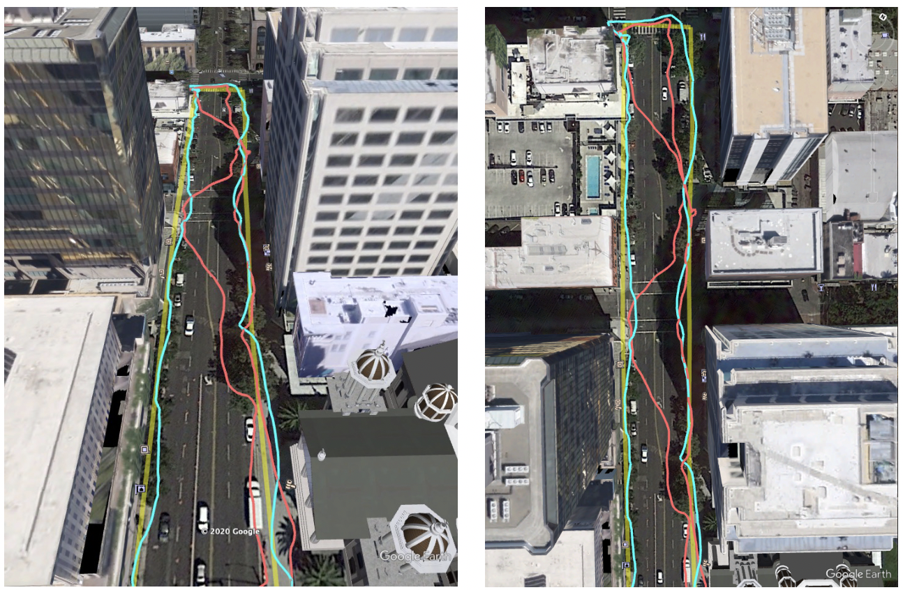
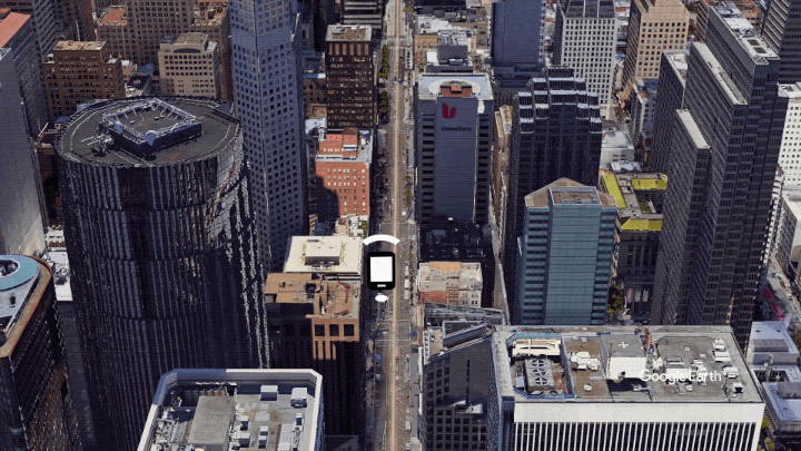
This wrong-side-of-the-street position error is caused by reflected GPS signals in cities,
이 잘못된 길목 위치 에러는 도시에서 GPS 시그널들이 반사되며 발생하며
and we embarked on an ambitious project to help solve this great problem in GPS.
우리는 GPS 중요한 문제를 해결하기 위해 야심찬 프로젝트를 착수했습니다.
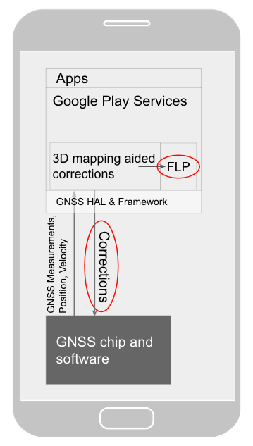
Our solution uses 3D mapping aided corrections, and is only feasible to be done at scale by Google because it comprises 3D building models, raw GPS measurements, and machine learning.
우리 솔루션은 3D 맵핑을 사용하며 이것은 3d 건물 모델과 GPS 측정 그리고 머신러닝으로 구성되어 있기 때문에 오직 구글에서 수행될 수 있습니다.
The December Pixel Feature Drop adds 3D mapping aided GPS corrections to Pixel 5 and Pixel 4a (5G).
12월 픽셀은 3d 매핑 gps보정을 픽셀기기에 추가했습니다.
With a system API that provides feedback to the Qualcomm® Snapdragon™ 5G Mobile Platform that powers Pixel,
픽셀을 움직이게하는 퀄텀 스냅드로곤 플랫폼에 사용하는 시스템 API를 사용하면
the accuracy in cities (or “urban canyons”) improves spectacularly.
도시(도시협곡)에서 정확도가 크게 향상됩니다.
Why hasn’t this been solved before?
The problem is that GPS constructively locates you in the wrong place when you are in a city.
이 문제는 당신이 도시에 있을 때 GPS는 구조적으로 당신을 잘못되게 위치시킵니다.
This is because all GPS systems are based on line-of-sight operation from satellites.
왜냐하면 모든 GPS 시스템은 위성으로부터 가시광선에 기반하기 때문입니다.
But in big cities, most or all signals reach you through non line-of-sight reflections, because the direct signals are blocked by the buildings.
하지만 대도시에서 대부분 혹은 모든 신호들은 가시광선들은 반사되어 당신에게 도달하는데 이는 직접적인 신호들이 빌딩들에 의해 차단되기 때문입니다.
The GPS chip assumes that the signal is line-of-sight and therefore introduces error when it calculates the excess path length that the signals traveled.
GPS칩은 가시광선 신호를 추정하므로 신호 추적 시 경로 거리 계산 시 에러가 발생하게 됩니다.
The most common side effect is that your position appears on the wrong side of the street,
대부분의 부작용은 당신의 위치가 잘못된 거리에 나타나는 것
although your position can also appear on the wrong city block, especially in very large cities with many skyscrapers.
비록 당신의 위치가 잘못된 도시 블럭에 나타나더라도, 특히 매우 큰 빌딩들이 있는 도시에 있더라도
There have been attempts to address this problem for more than a decade. But no solution existed at scale,
그것은 이런 문제를 해결하기위해 10년 이상 시도해왔습니다. 그러나 해결방법은 존재하지 않았습니다.
until 3D mapping aided corrections were launched on Android.
3D 매핑 수정이 안드로이드에 출시되기 전까지..
How 3D mapping aided corrections work
The 3D mapping aided corrections module, in Google Play services, includes tiles of 3D building models that Google has for more than 3850 cities around the world.
구글 플레이 서비스에서 3d mapping aided corrections(이하 3d)는 전 세계에 있는 3850개 이상의 도시를 가진 구글 모듈을 포함하고 있습니다.
Google Play services 3D mapping aided corrections currently supports pedestrian use-cases only.
구글 플레이는 현재 3d를 오직 보행용으로 제공하고 있습니다.
When you use your device’s GPS while walking, Android’s Activity Recognition API will recognize that you are a pedestrian, and if you are in one of the 3850+ cities, tiles with 3D models will be downloaded and cached on the phone for that city.
당신이 걷는동안 당신의 디바이스의 GPS가 안드로이드 API를 인식하고 3850개 이상의 도시 중에 당신이 있다면 3d는 해당 도시에 대한 정보를 기기에 저장할 것입니다.
Cache size is approximately 20MB, which is about the same size as 6 photographs.
캐시 사이즈는 대략 20메가이며 사진 6장과 비슷합니다.
Inside the module, the 3D mapping aided corrections algorithms solve the chicken-and-egg problem, which is: if the GPS position is not in the right place, then how do you know which buildings are blocking or reflecting the signals?
모듈 내부에서 3d 알고리즘은 치킨 달걀 문제(닭이먼저냐 달걀이 먼저냐?)를 해결합니다 즉 GPS 위치가 올바른 위치에 있지 않는다면 당신은 어떻게 어떤 건물이 막고있거나 신호를 반사하는지 알 수 있습니까?
Having solved this problem, 3D mapping aided corrections provide a set of corrected positions to the FLP.
이 문제를 해결하기 위해 3d는 FLP에 수정된 위치를 제공합니다.
A system API then provides this information to the GPS chip to help the chip improve the accuracy of the next GPS fix.
시스템 api는 gps칩에 다음 gps 정확성을 향상시키기 위해 정보를 제공합니다.
With this December Pixel feature drop, we are releasing version 2 of 3D mapping aided corrections on Pixel 5 and Pixel 4a (5G).
이번 12월에 픽셀 기능 삭제와 함꼐 3d버전의 버전2을 탑재한 픽셀 5와 4a를 출시합니다.
This reduces wrong-side-of-street occurrences by approximately 75%. Other Android phones, using Android 8 or later, have version 1 implemented in the FLP, which reduces wrong-side-of-street occurrences by approximately 50%.
이를 통해 길에서 발생하는 사고가 대략 75% 줄어듭니다. android 8이상을 사용하는 안드로이드 폰드에서도 FLP 버전1이 구현되어 있어서 길가에서 발생하는 사고 50%가 감소합니다.
Version 2 will be available to the entire Android ecosystem (Android 8 or later) in early 2021.
버전2는 21년초에 안드로이드 생태계에서 사용가능할 것입니다.
Android’s 3D mapping aided corrections work with signals from the USA’s Global Positioning System (GPS) as well as other Global Navigation Satellite Systems (GNSSs): GLONASS, Galileo, BeiDou, and QZSS.
안드로이드의 3d는 GNSSs뿐만아니라 GPS에서 작동합니다.
Our GPS chip partners shared the importance of this work for their technologies:
우리의 GPS칩 파트너들은 그들의 기술에대한 작업의 중요성을 공유했습니다.
“Consumers rely on the accuracy of the positioning and navigation capabilities of their mobile phones.
소비자들은 정확한 위치에 의존하고 모바일 폰의 탐색 기능에 의존합니다.
Location technology is at the heart of ensuring you find your favorite restaurant and you get your rideshare service in a timely manner.
위치 기술은 좋아하는 식당을 찾고 차량공유 서비스를 받을 수 있도록 하는 핵심기술입니다.
Qualcomm Technologies is leading the charge to improve consumer experiences with its newest Qualcomm® Location Suite technology featuring integration with Google's 3D mapping aided corrections.
퀄컴 테크노지스는 구글의 3d 기능과 통합된 최신 기술을 통해 사용자 경험을 향상시키는걸 주도하고 있습니다.
This collaboration with Google is an important milestone toward sidewalk-level location accuracy,” said Francesco Grilli, vice president of product management at Qualcomm Technologies, Inc.
구글과의 콜라보는 보도 수준의 위치 정확도를 향한 중요한 이정표라고 퀄컴의 관리자 Grilli가 말했습니다.
“Google's 3D mapping aided corrections is a major advancement in personal location accuracy for smartphone users when walking in urban environments.
구글의 3d는 도시환경에서 사용자가 걸을 때 개인 위치 정확도를 향상시킨것입니다.