
ShapeFile (Vector Data)은 흔히 볼 수 있는 GIS Data 형태로 점, 선, 다각형으로 이루어져 있으며 확대 및 축소를 진행하여도 선명한 데이터를 확인 할 수 있습니다. Raster Data는 픽셀 다위의 데이터를 저장하는 행렬의 데이터 구조를 가지며 픽셀에 담기는 데이터에 따라 선명도가 나뉩니다.
ShapeFile 형태의 GIS Data를 DB에 저장하고 관리하고 싶다면 Postgresql의 확장인 PostGIS를 추천합니다.
인덱싱을 진행할 데이터는 전 세계 대륙 데이터와 해안선 데이터 두 가지입니다.
링크를 통해 데이터를 다운로드 받을 수 있습니다.
Django는 GeoDjango라는 컨셉을 가지고 있는데 GIS 데이터를 다룰 수 있는 ORM과 함수 등을 가지고 있습니다.
다음의 GeoDjango를 통해 Shapefile을 DB에 인덱싱 해보도록 하겠습니다.
GeoDjango Introduce
GeoDjango intends to be a
world-class geographicweb framework. Its goal is to make it as easy as possible to buildGIS web applicationsand harness the power of spatially enabled data.
- OGC geometries 와 raster data를 위한
Django Model 필드 - Spatial Data에 대한
Django ORM 제공 - GIS geometry와 raster 작업 및 다양한 형식의 데이터 조작을 위한 Loose-coupled, high-level 파이썬 인터페이스 조작
AdminPage에서 Geometry 필드 편집
Install
Python & Django
| Django Version | Python Versions |
|---|---|
| 2.2 | 3.5, 3.6, 3.7, 3.8 (added in 2.2.8), 3.9 (added in 2.2.17) |
| 3.0 | 3.6, 3.7, 3.8, 3.9 (added in 3.0.11) |
| 3.1 | 3.6, 3.7, 3.8, 3.9 (added in 3.1.3) |
| 3.2 | 3.6, 3.7, 3.8, 3.9, 3.10 (added in 3.2.9) |
| 4.0 | 3.8, 3.9, 3.10 |
Spatial Database
PostGIS is recommended, because it is the most mature and feature-rich open source spatial database.
| Database | Library Requirements | Supported Versions | Notes |
|---|---|---|---|
| PostgreSQL | GEOS,GDAL,PROJ,PostGIS | 10+ | Requires PostGIS |
| MySQL | GEOS,GDAL | 5.7+ | Limited Functionally |
| Oracle | GEOS,GDAL | 19+ | XE not supported |
| SQLite | GEOS,GDAL,PROJ,SpatialLite | 3.9.0+ | Requires SpatialLite 4.3+ |
$ brew install postgresql
$ brew install postgis
$ brew install gdal
$ brew install libgeoip
Setting Up
-
Create a New Project
$ django-admin startproject geodjango$ cd geodjango $ python manage.py startapp world -
Configure settings.py
- Edit the database connection settings to math your setup
DATABASES = { 'default': { 'ENGINE': 'django.contrib.gis.db.backends.postgis', 'NAME': 'geodjango', 'USER': 'geo', }, }- Modify the
[INSTALLED_APPS](https://docs.djangoproject.com/en/4.0/ref/settings/#std-setting-INSTALLED_APPS)setting to include[django.contrib.admin](https://docs.djangoproject.com/en/4.0/ref/contrib/admin/#module-django.contrib.admin),[django.contrib.gis](https://docs.djangoproject.com/en/4.0/ref/contrib/gis/#module-django.contrib.gis), and{Own App}
INSTALLED_APPS = [
    'django.contrib.admin',
    'django.contrib.auth',
    'django.contrib.contenttypes',
    'django.contrib.sessions',
    'django.contrib.messages',
    'django.contrib.staticfiles',
    'django.contrib.gis',
    '{Own App}',
]
Model API
- Spatial Field Types
- GeometryField
- PointField
pnt = Point(5, 23) pnt = Point([5, 23]) - LineStringField
ls = LineString((0, 0), (1, 1)) ls = LineString(Point(0, 0), Point(1, 1)) ls = LineString( ((0, 0), (1, 1)) ) ls = LineString( [Point(0, 0), Point(1, 1)] ) - PolygonField
ext_coords = ((0, 0), (0, 1), (1, 1), (1, 0), (0, 0)) int_coords = ((0.4, 0.4), (0.4, 0.6), (0.6, 0.6), (0.6, 0.4), (0.4, 0.4)) poly = Polygon(ext_coords, int_coords) poly = Polygon(LinearRing(ext_coords), LinearRing(int_coords)) - MultiPointField
mp = MultiPoint(Point(0, 0), Point(1, 1)) mp = MultiPoint( (Point(0, 0), Point(1, 1)) ) - MultiLineStringField
ls1 = LineString((0, 0), (1, 1)) ls2 = LineString((2, 2), (3, 3)) mls = MultiLineString(ls1, ls2) mls = MultiLineString([ls1, ls2]) - MultiPolygonField
p1 = Polygon( ((0, 0), (0, 1), (1, 1), (0, 0)) ) p2 = Polygon( ((1, 1), (1, 2), (2, 2), (1, 1)) ) mp = MultiPolygon(p1, p2) mp = MultiPolygon([p1, p2]) - GeometryCollectionField
poly = Polygon( ((0, 0), (0, 1), (1, 1), (0, 0)) ) gc = GeometryCollection(Point(0, 0), MultiPoint(Point(0, 0), Point(1, 1)), poly) gc = GeometryCollection((Point(0, 0), MultiPoint(Point(0, 0), Point(1, 1)), poly)) - RasterField
- Spatial Field Options
- srid
- Sets the SRID(Spatial Reference System Identity) of the geometry field to the given value.
- Default : 4326 (= WGS84)
- spatial_index
- Defalut : True
- srid
- Geometry Field Options
- dim (차원)
- Dimension
- This option may be used for customizing the coordinate dimension of the geometry field.
- Default : 2
- geography (지리)
- If set to True, this option will create a database column of type geography, rather than geometry.(Geography support is limited to PostGIS and will force the SRID to be 4326.)
- dim (차원)
GDAL
GeoDjango provides a high-level Python interface for some of the capabilities of OGR, including the reading and coordinate transformation of vector spatial data and minimal support for GDAL’s features with respect to raster (image) data.
GeoDjango는 벡터 공간 데이터의 읽기 및 좌표 변환(OGR)과 Raster(이미지) 데이터와 관련해서 (GDAL) 최소한의 기능을 지원- 기능 종류
- 데이터 생성
GDALRaster>>> rst = GDALRaster({ # Creates an in-memory raster ... 'srid': 4326, ... 'width': 4, ... 'height': 4, ... 'datatype': 1, ... 'bands': [{ ... 'data': (2, 3), ... 'offset': (1, 1), ... 'size': (2, 2), ... 'shape': (2, 1), ... 'nodata_value': 5, ... }] ... })
- 데이터 변환
GDALRaster.transform- Rater를 다른 srs(spatial reference system)으로 변환>>> rst = GDALRaster({ ... "width": 6, "height": 6, "srid": 3086, ... "origin": [500000, 400000], ... "scale": [100, -100], ... "bands": [{"data": range(36), "nodata_value": 99}] ... }) >>> target_srs = SpatialReference(4326) >>> target = rst.transform(target_srs) >>> target.origin [-82.98492744885776, 27.601924753080144]GDALRaster.geotransform- geotransform>>> rst = GDALRaster({'width': 10, 'height': 20, 'srid': 4326}) >>> rst.geotransform [0.0, 1.0, 0.0, 0.0, 0.0, -1.0]CoordTransform- 좌표계 변환>>> ct = CoordTransform(SpatialReference('WGS84'), SpatialReference('NAD83')) >>> for feat in layer: ... geom = feat.geom # getting clone of feature geometry ... geom.transform(ct) # transforming
- 데이터 정보 조회
GDALRaster- info - 기존
GDAL의gdalinfo와 같은 기능 - metadata
>>> rst = GDALRaster({'width': 10, 'height': 20, 'srid': 4326}) >>> rst.metadata {} >>> rst.metadata = {'DEFAULT': {'OWNER': 'Django', 'VERSION': '1.0'}} >>> rst.metadata {'DEFAULT': {'OWNER': 'Django', 'VERSION': '1.0'}} >>> rst.metadata = {'DEFAULT': {'OWNER': None, 'VERSION': '2.0'}} >>> rst.metadata {'DEFAULT': {'VERSION': '2.0'}} - name
- width
- height
- scale
- skew
- extend
- bands
- driver
- srs
- srid
- origin
- vsi_buffer
- is_vsi_based
- info - 기존
- 데이터 처리
- 데이터 생성
Importing Spatial Data
Ogrinspect
$ python manage.py ogrinspect [options] <data_source> <model_name> [options]$ python manage.py ogrinspect world_boundary/data/World_Continents/World_Continents.shp WorldContinents --srid=4326 --mapping --multi- The
-srid=4326option sets the SRID for the geographic field. - The
-mappingoption tellsogrinspectto also generate a mapping dictionary for use with[LayerMapping](https://docs.djangoproject.com/en/4.1/ref/contrib/gis/layermapping/#django.contrib.gis.utils.LayerMapping). - The
-multioption is specified so that the geographic field is a[MultiPolygonField](https://docs.djangoproject.com/en/4.1/ref/contrib/gis/model-api/#django.contrib.gis.db.models.MultiPolygonField)instead of just a[PolygonField](https://docs.djangoproject.com/en/4.1/ref/contrib/gis/model-api/#django.contrib.gis.db.models.PolygonField).
# This is an auto-generated Django model module created by ogrinspect.
from django.contrib.gis.db import models

class WorldContinents(models.Model):
    fid = models.IntegerField()
    continent = models.CharField(max_length=13)
    sqmi = models.FloatField()
    sqkm = models.FloatField()
    shape__are = models.FloatField()
    shape__len = models.FloatField()
    geom = models.MultiPolygonField(srid=4326)

# Auto-generated `LayerMapping` dictionary for WorldContinents model
worldcontinents_mapping = {
    'fid': 'FID',
    'continent': 'CONTINENT',
    'sqmi': 'SQMI',
    'sqkm': 'SQKM',
    'shape__are': 'Shape__Are',
    'shape__len': 'Shape__Len',
    'geom': 'MULTIPOLYGON',
}
Layer Mapping
from pathlib import Path
from django.contrib.gis.utils import LayerMapping
from .models import WorldBorder, WorldContinents

world_mapping = {
    'fips' : 'FIPS',
    'iso2' : 'ISO2',
    'iso3' : 'ISO3',
    'un' : 'UN',
    'name' : 'NAME',
    'area' : 'AREA',
    'pop2005' : 'POP2005',
    'region' : 'REGION',
    'subregion' : 'SUBREGION',
    'lon' : 'LON',
    'lat' : 'LAT',
    'mpoly' : 'MULTIPOLYGON',
}

world_shp = Path(__file__).resolve().parent / 'data' / 'TM_WORLD_BORDERS-0.3.shp'

def run(verbose=True):
    lm = LayerMapping(WorldBorder, world_shp, world_mapping, transform=False)
    lm.save(strict=True, verbose=verbose)

worldcontinents_mapping = {
    'fid': 'FID',
    'continent': 'CONTINENT',
    'sqmi': 'SQMI',
    'sqkm': 'SQKM',
    'shape_are': 'Shape__Are',
    'shape_len': 'Shape__Len',
    'geom': 'MULTIPOLYGON',
}

worldcontinents_shp = Path(__file__).resolve().parent / 'data' / 'World_Continents' /'World_Continents.shp'

def run_continents(verbose=True):
    lm = LayerMapping(WorldContinents, worldcontinents_shp, worldcontinents_mapping, transform=False)
    lm.save(strict=True, verbose=verbose)
python manage.py shell
>>> from world_boundary import load
>>> load.run()
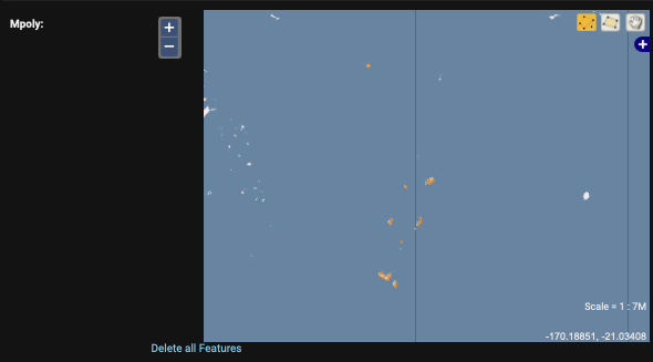
>>> load.run_continents()Geographic Admin
- ModelAdmin
from django.contrib.gis import admin
from .models import {My Model}

admin.site.register({My Model}, admin.ModelAdmin)
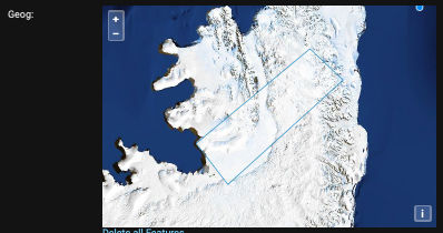
S1B_EW_RAW__0SDH_20200301T011115_20200301T011135_020491_026D3F_5878.SAFE- GISModelAdmin
from django.contrib.gis import admin
from .models import {My Model}

admin.site.register({My Model}, admin.GISModelAdmin)
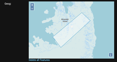
S1B_EW_RAW__0SDH_20200301T011115_20200301T011135_020491_026D3F_5878.SAFE- GeoModelAdmin
from django.contrib.gis import admin
from .models import {My Model}

admin.site.register({My Model}, admin.GeoModelAdmin)
GeoDjango를 사용하면 Django Model 생성부터 인덱싱 작업까지 손 쉽게 진행 할 수 있음을 알 수 있었습니다.
Reference