저번에 sdk까지 설치하고 프로젝트까지 권한을 주었다.
이번에는 직접 Google Maps API를 이용하여 지도를 띄우고, 장소 검색까지 해보겠다.
내가 필요한 기능은 '동물병원' 찾기
Maps API 중 place 기능을 이용했다.
먼저 jsp 안에 script 문으로 구글 맵과 place 기능을 불러온다.
<script src="https://maps.googleapis.com/maps/api/js?key=[api_key]&callback=initMap&libraries=places&v=weekly&radius=5000"></script>여기서 [api_key] 부분에 자신의 api key 를 넣어주면 된다.
google에서 제공해주는 샘플 코드를 이용해서 작성했는데 첫 위치를 한국으로 잡고 싶어서 kr을 추가했다.
<script>
      // This example uses the autocomplete feature of the Google Places API.
      // It allows the user to find all hotels in a given place, within a given
      // country. It then displays markers for all the hotels returned,
      // with on-click details for each hotel.
      // This example requires the Places library. Include the libraries=places
      // parameter when you first load the API. For example:
      // <script src="https://maps.googleapis.com/maps/api/js?key=YOUR_API_KEY&libraries=places">
      let map;
      let places;
      let infoWindow;
      let markers = [];
      let autocomplete;
      const countryRestrict = { country: "kr" };
      const MARKER_PATH =
        "https://developers.google.com/maps/documentation/javascript/images/marker_green";
      const hostnameRegexp = new RegExp("^https?://.+?/");
      const countries = {


        //(코드 생략)


        kr: {
          center : { lat: 37.5642135 ,lng: 127.0016985 },
          zoom: 16,
        },

      };
initMap 함수에서도 kr로 위치를 잡아준다.
function initMap() {
        map = new google.maps.Map(document.getElementById("map"), {
          zoom: countries["kr"].zoom,
          center: countries["kr"].center,
          mapTypeControl: true,
          panControl: true,
          zoomControl: true,
          streetViewControl: true,
        });
        infoWindow = new google.maps.InfoWindow({
          content: document.getElementById("info-content"),
        });
        // Create the autocomplete object and associate it with the UI input control.
        // Restrict the search to the default country, and to place type "cities".
        autocomplete = new google.maps.places.Autocomplete(
          document.getElementById("autocomplete"),
          {
            types: ["(cities)"],
            componentRestrictions: countryRestrict,
          }
        );
        places = new google.maps.places.PlacesService(map);
        autocomplete.addListener("place_changed", onPlaceChanged);
        // Add a DOM event listener to react when the user selects a country.
        document
          .getElementById("country")
          .addEventListener("change", setAutocompleteCountry);
      }
그리고 내가 도시를 입력했을 때,
자동으로 '동물병원'이 검색되도록 google에서 제공해주는 type을 지정한다.
// Search for hotels in the selected city, within the viewport of the map.
      function search() {
        const search = {
          bounds: map.getBounds(),
          types: ["veterinary_care"],
        };
        places.nearbySearch(search, (results, status, pagination) => {
          if (status === google.maps.places.PlacesServiceStatus.OK && results) {
            clearResults();
            clearMarkers();

            // Create a marker for each hotel found, and
            // assign a letter of the alphabetic to each marker icon.
            for (let i = 0; i < results.length; i++) {
              const markerLetter = String.fromCharCode(
                "A".charCodeAt(0) + (i % 26)
              );
              const markerIcon = MARKER_PATH + markerLetter + ".png";
              // Use marker animation to drop the icons incrementally on the map.
              markers[i] = new google.maps.Marker({
                position: results[i].geometry.location,
                animation: google.maps.Animation.DROP,
                icon: markerIcon,
              });
              // If the user clicks a hotel marker, show the details of that hotel
              // in an info window.
              markers[i].placeResult = results[i];
              google.maps.event.addListener(
                markers[i],
                "click",
                showInfoWindow
              );
              setTimeout(dropMarker(i), i * 100);
              addResult(results[i], i);
            }
          }
        });
      }
const search = {
bounds: map.getBounds(),
types: ["veterinary_care"],
};
이 부분이 핵심이다.
자신이 원하는 type을 정해주면 되는데
google에서 제공해주는 타입만 검색 가능하므로 미리 조사해두면 나중에 고생을 덜 한다.
나는 그걸 몰랐어서 구글에 직접 메일을 보내고 답변을 통해 알게 되었다.
https://developers.google.com/maps/documentation/places/web-service/supported_types?hl=fi
나머지 샘플코드는 고치지 않아도 되므로
body 부분 안에
<div class="hospital-search">
      <div id="findhospital">Find hospital in:</div>

      <div id="locationField">
        <input id="autocomplete" placeholder="Enter a city" type="text" />
      </div>

      <div id="controls">
        <select id="country">
          <!--코드 생략-->
          <option value="kr" selected>Korea</option>
        </select>
      </div>
    </div>

    <div id="map" style="height: 480px; position: relative; overflow: hidden;"></div>
나머지 list 부분은 수정하지 않았다.
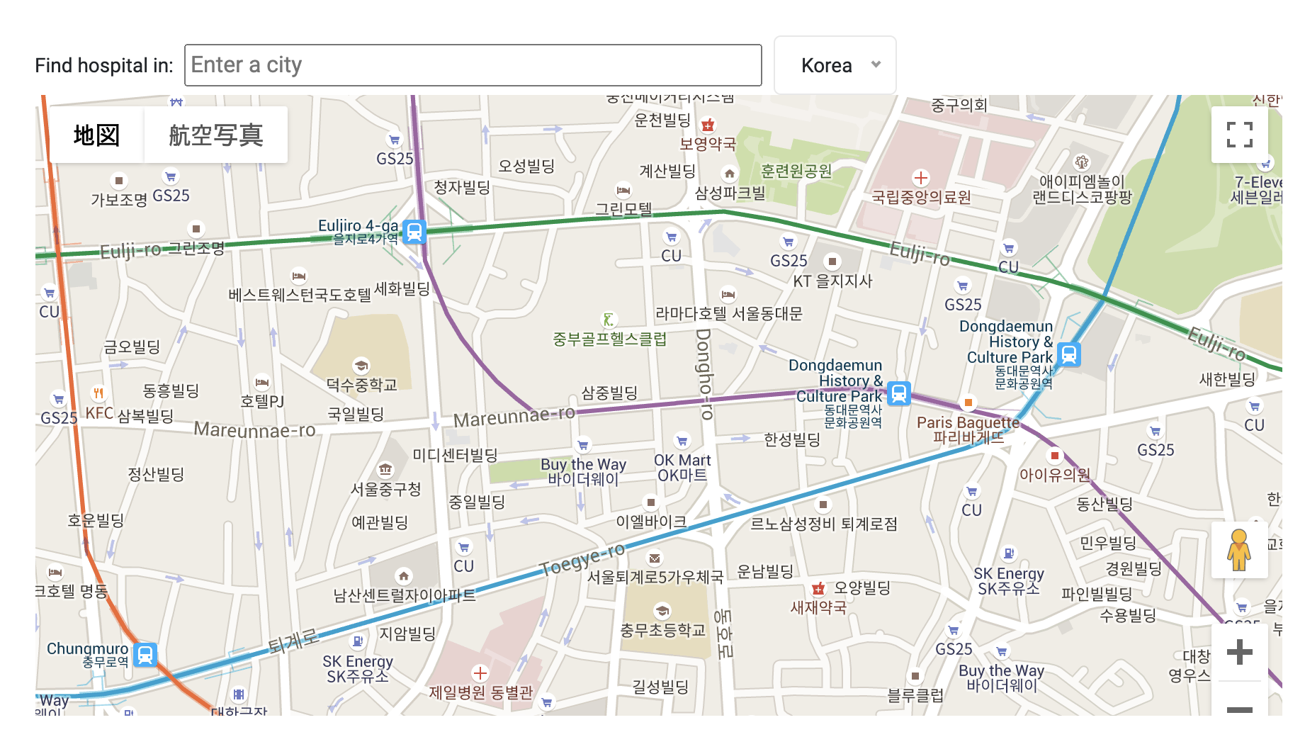
화면을 구동하면 구글 맵이 뜰거고 검색창에 seoul 이라고 입력하면 밑에 자동으로 대한민국 서울이라고 뜰거다.
누르게 되면
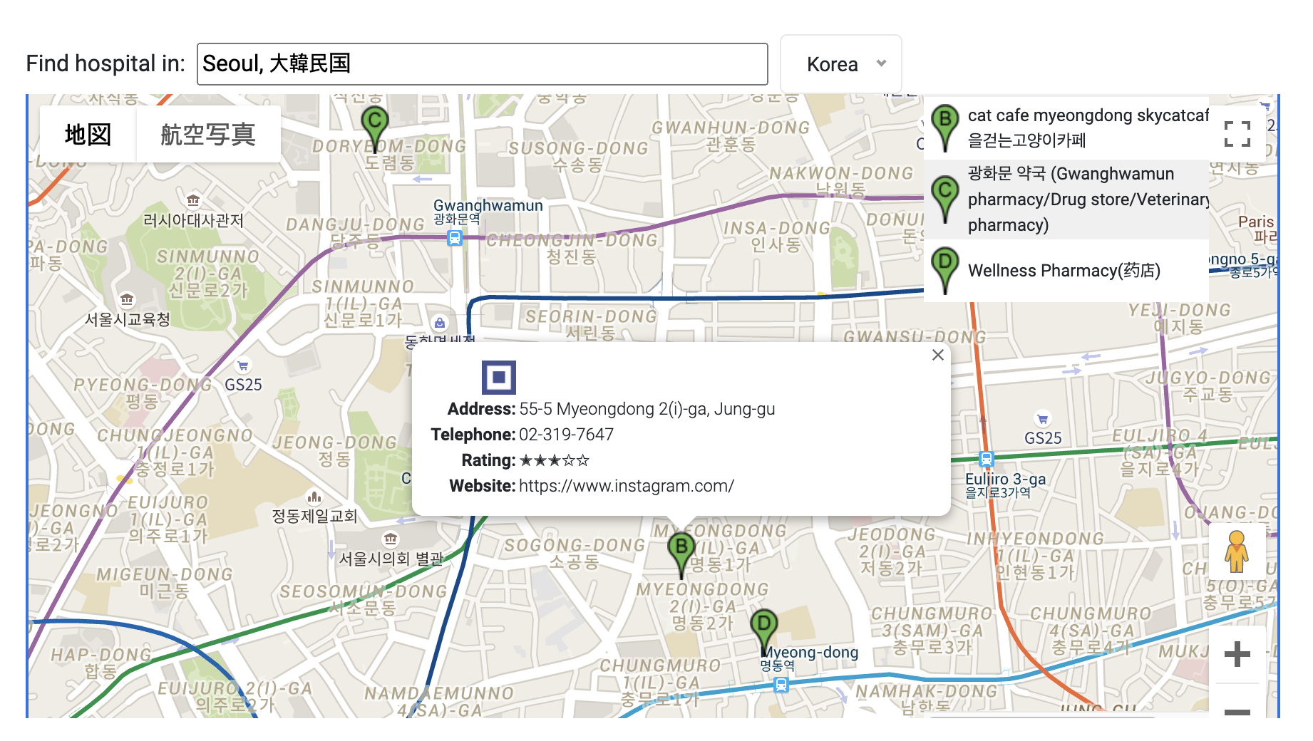
오른쪽에 동물병원 리스트가 뜬 것을 볼 수 있고, 리스트 항목을 눌렀을 때 정보를 볼 수 있다.
하지만 나는 도시보다는 현재 위치에서 동물병원을 검색하고 싶었으며, 리스트 항목이 적어 이 방법을 포기하고 다른 방법으로 접근하였다.
다음 글로 작성할 예정,,
// 총 코드 (부트스트랩 제거)
// map.jsp
<%@ page language="java" contentType="text/html; charset=UTF-8"
pageEncoding="UTF-8"%>
<%@ taglib prefix="c" uri="http://java.sun.com/jsp/jstl/core" %>
<!doctype html>
<html>
<head>
<meta charset="utf-8">
<title>Map </title>
<!-- test2 -->
<style type="text/css">
/* Always set the map height explicitly to define the size of the div
* element that contains the map. */
#map {
height: 100%;
}
/* Optional: Makes the sample page fill the window. */
html,
body {
height: 100%;
margin: 0;
padding: 0;
}
body {
padding: 0 !important;
}
table {
font-size: 12px;
}
.hospital-search {
-webkit-box-align: center;
-ms-flex-align: center;
align-items: center;
background: #fff;
display: -webkit-box;
display: -ms-flexbox;
display: flex;
left: 0;
position: absolute;
top: 0;
width: 880px;
z-index: 1;
}
#map {
margin-top: 40px;
width: 880px;
}
#listing {
position: absolute;
width: 200px;
height: 490px;
overflow: auto;
left: 630px;
top: 0px;
cursor: pointer;
overflow-x: hidden;
}
#findhospitals {
font-size: 14px;
}
#locationField {
-webkit-box-flex: 1 1 190px;
-ms-flex: 1 1 190px;
flex: 1 1 190px;
margin: 0 8px;
}
#controls {
-webkit-box-flex: 1 1 140px;
-ms-flex: 1 1 140px;
flex: 1 1 140px;
}
#autocomplete {
width: 100%;
}
#country {
width: 100%;
}
.placeIcon {
width: 20px;
height: 34px;
margin: 4px;
}
.hospitalIcon {
width: 24px;
height: 24px;
}
#resultsTable {
border-collapse: collapse;
width: 240px;
}
#rating {
font-size: 13px;
font-family: Arial Unicode MS;
}
.iw_table_row {
height: 18px;
}
.iw_attribute_name {
font-weight: bold;
text-align: right;
}
.iw_table_icon {
text-align: right;
}
</style>
<script>
// This example uses the autocomplete feature of the Google Places API.
// It allows the user to find all hospitals in a given place, within a given
// country. It then displays markers for all the hospitals returned,
// with on-click details for each hospital.
// This example requires the Places library. Include the libraries=places
// parameter when you first load the API. For example:
// <script src="https://maps.googleapis.com/maps/api/js?key=YOUR_API_KEY&libraries=places">
let map;
let places;
let infoWindow;
let markers = [];
let autocomplete;
const countryRestrict = { country: "kr" };
const MARKER_PATH =
"https://developers.google.com/maps/documentation/javascript/images/marker_green";
const hostnameRegexp = new RegExp("^https?://.+?/");
const countries = {
au: {
center: { lat: -25.3, lng: 133.8 },
zoom: 4,
},
br: {
center: { lat: -14.2, lng: -51.9 },
zoom: 3,
},
ca: {
center: { lat: 62, lng: -110.0 },
zoom: 3,
},
fr: {
center: { lat: 46.2, lng: 2.2 },
zoom: 5,
},
de: {
center: { lat: 51.2, lng: 10.4 },
zoom: 5,
},
mx: {
center: { lat: 23.6, lng: -102.5 },
zoom: 4,
},
nz: {
center: { lat: -40.9, lng: 174.9 },
zoom: 5,
},
it: {
center: { lat: 41.9, lng: 12.6 },
zoom: 5,
},
za: {
center: { lat: -30.6, lng: 22.9 },
zoom: 5,
},
es: {
center: { lat: 40.5, lng: -3.7 },
zoom: 5,
},
pt: {
center: { lat: 39.4, lng: -8.2 },
zoom: 6,
},
us: {
center: { lat: 37.1, lng: -95.7 },
zoom: 3,
},
uk: {
center: { lat: 54.8, lng: -4.6 },
zoom: 5,
},
kr: {
center : { lat: 37.5642135 ,lng: 127.0016985 },
zoom: 16,
},
};
function initMap() {
map = new google.maps.Map(document.getElementById("map"), {
zoom: countries["kr"].zoom,
center: countries["kr"].center,
mapTypeControl: true,
panControl: true,
zoomControl: true,
streetViewControl: true,
});
infoWindow = new google.maps.InfoWindow({
content: document.getElementById("info-content"),
});
// Create the autocomplete object and associate it with the UI input control.
// Restrict the search to the default country, and to place type "cities".
autocomplete = new google.maps.places.Autocomplete(
document.getElementById("autocomplete"),
{
types: ["(cities)"],
componentRestrictions: countryRestrict,
}
);
places = new google.maps.places.PlacesService(map);
autocomplete.addListener("place_changed", onPlaceChanged);
// Add a DOM event listener to react when the user selects a country.
document
.getElementById("country")
.addEventListener("change", setAutocompleteCountry);
}
// When the user selects a city, get the place details for the city and
// zoom the map in on the city.
function onPlaceChanged() {
const place = autocomplete.getPlace();
if (place.geometry && place.geometry.location) {
map.panTo(place.geometry.location);
map.setZoom(15);
search();
} else {
document.getElementById("autocomplete").placeholder = "Enter a city";
}
}
// Search for hospitals in the selected city, within the viewport of the map.
function search() {
const search = {
bounds: map.getBounds(),
types: ["veterinary_care"],
};
places.nearbySearch(search, (results, status, pagination) => {
if (status === google.maps.places.PlacesServiceStatus.OK && results) {
clearResults();
clearMarkers();
// Create a marker for each hospital found, and
// assign a letter of the alphabetic to each marker icon.
for (let i = 0; i < results.length; i++) {
const markerLetter = String.fromCharCode(
"A".charCodeAt(0) + (i % 26)
);
const markerIcon = MARKER_PATH + markerLetter + ".png";
// Use marker animation to drop the icons incrementally on the map.
markers[i] = new google.maps.Marker({
position: results[i].geometry.location,
animation: google.maps.Animation.DROP,
icon: markerIcon,
});
// If the user clicks a hospital marker, show the details of that hospital
// in an info window.
markers[i].placeResult = results[i];
google.maps.event.addListener(
markers[i],
"click",
showInfoWindow
);
setTimeout(dropMarker(i), i * 100);
addResult(results[i], i);
}
}
});
}
function clearMarkers() {
for (let i = 0; i < markers.length; i++) {
if (markers[i]) {
markers[i].setMap(null);
}
}
markers = [];
}
// Set the country restriction based on user input.
// Also center and zoom the map on the given country.
function setAutocompleteCountry() {
const country = document.getElementById("country").value;
if (country == "all") {
autocomplete.setComponentRestrictions({ country: [] });
map.setCenter({ lat: 15, lng: 0 });
map.setZoom(2);
} else {
autocomplete.setComponentRestrictions({ country: country });
map.setCenter(countries[country].center);
map.setZoom(countries[country].zoom);
}
clearResults();
clearMarkers();
}
function dropMarker(i) {
return function () {
markers[i].setMap(map);
};
}
function addResult(result, i) {
const results = document.getElementById("results");
const markerLetter = String.fromCharCode("A".charCodeAt(0) + (i % 26));
const markerIcon = MARKER_PATH + markerLetter + ".png";
const tr = document.createElement("tr");
tr.style.backgroundColor = i % 2 === 0 ? "#F0F0F0" : "#FFFFFF";
tr.onclick = function () {
google.maps.event.trigger(markers[i], "click");
};
const iconTd = document.createElement("td");
const nameTd = document.createElement("td");
const icon = document.createElement("img");
icon.src = markerIcon;
icon.setAttribute("class", "placeIcon");
icon.setAttribute("className", "placeIcon");
const name = document.createTextNode(result.name);
iconTd.appendChild(icon);
nameTd.appendChild(name);
tr.appendChild(iconTd);
tr.appendChild(nameTd);
results.appendChild(tr);
}
function clearResults() {
const results = document.getElementById("results");
while (results.childNodes[0]) {
results.removeChild(results.childNodes[0]);
}
}
// Get the place details for a hospital. Show the information in an info window,
// anchored on the marker for the hospital that the user selected.
function showInfoWindow() {
const marker = this;
places.getDetails(
{ placeId: marker.placeResult.place_id },
(place, status) => {
if (status !== google.maps.places.PlacesServiceStatus.OK) {
return;
}
infoWindow.open(map, marker);
buildIWContent(place);
}
);
}
// Load the place information into the HTML elements used by the info window.
function buildIWContent(place) {
document.getElementById("iw-icon").innerHTML =
'<img class="hospitalIcon" ' + 'src="' + place.icon + '"/>';
document.getElementById("iw-url").innerHTML =
'<b><a href="' + place.url + '">' + place.name + "</a></b>";
document.getElementById("iw-address").textContent = place.vicinity;
if (place.formatted_phone_number) {
document.getElementById("iw-phone-row").style.display = "";
document.getElementById("iw-phone").textContent =
place.formatted_phone_number;
} else {
document.getElementById("iw-phone-row").style.display = "none";
}
// Assign a five-star rating to the hospital, using a black star ('✭')
// to indicate the rating the hospital has earned, and a white star ('✩')
// for the rating points not achieved.
if (place.rating) {
let ratingHtml = "";
for (let i = 0; i < 5; i++) {
if (place.rating < i + 0.5) {
ratingHtml += "✩";
} else {
ratingHtml += "✭";
}
document.getElementById("iw-rating-row").style.display = "";
document.getElementById("iw-rating").innerHTML = ratingHtml;
}
} else {
document.getElementById("iw-rating-row").style.display = "none";
}
// The regexp isolates the first part of the URL (domain plus subdomain)
// to give a short URL for displaying in the info window.
if (place.website) {
let fullUrl = place.website;
let website = String(hostnameRegexp.exec(place.website));
if (!website) {
website = "http://" + place.website + "/";
fullUrl = website;
}
document.getElementById("iw-website-row").style.display = "";
document.getElementById("iw-website").textContent = website;
} else {
document.getElementById("iw-website-row").style.display = "none";
}
}
</script>
</head>
<body>
<h2>Map</h2>
<!-- Hero Area End -->
<!-- ================ contact section start ================= -->
<section class="contact-section">
<div class="container">
<div class="d-none d-sm-block mb-5 pb-4">
<div id="MapID" style="height: 480px; position: relative; overflow: hidden;">
<div class="hospital-search">
<div id="findhospital">Find hospital in:</div>
<div id="locationField">
<input id="autocomplete" placeholder="Enter a city" type="text" />
</div>
<div id="controls">
<select id="country">
<!-- 코드생략 -->
<option value="kr" selected>Korea</option>
</select>
</div>
</div>
<div id="map" style="height: 480px; position: relative; overflow: hidden;"></div>
<div id="listing">
<table id="resultsTable">
<tbody id="results"></tbody>
</table>
</div>
<div style="display: none">
<div id="info-content">
<table>
<tr id="iw-url-row" class="iw_table_row">
<td id="iw-icon" class="iw_table_icon"></td>
<td id="iw-url"></td>
</tr>
<tr id="iw-address-row" class="iw_table_row">
<td class="iw_attribute_name">Address:</td>
<td id="iw-address"></td>
</tr>
<tr id="iw-phone-row" class="iw_table_row">
<td class="iw_attribute_name">Telephone:</td>
<td id="iw-phone"></td>
</tr>
<tr id="iw-rating-row" class="iw_table_row">
<td class="iw_attribute_name">Rating:</td>
<td id="iw-rating"></td>
</tr>
<tr id="iw-website-row" class="iw_table_row">
<td class="iw_attribute_name">Website:</td>
<td id="iw-website"></td>
</tr>
</table>
</div>
</div>
</div>
</div>
<script src="https://polyfill.io/v3/polyfill.min.js?features=default"></script>
<script src="https://maps.googleapis.com/maps/api/js?key=[api_key]&callback=initMap&libraries=places&v=weekly&radius=5000"></script>
</body>
</html>