Google Maps를 이용한 데이터 정리
import googlemaps
gmaps_key = 'AIzaSyBnjsDKM8TGvUV97-U1WnnagJ_vO4DPjHE'
gmaps = googlemaps.Client(key=gmaps_key)
# 예시
gmaps.geocode('서울영등포경찰서', language='ko')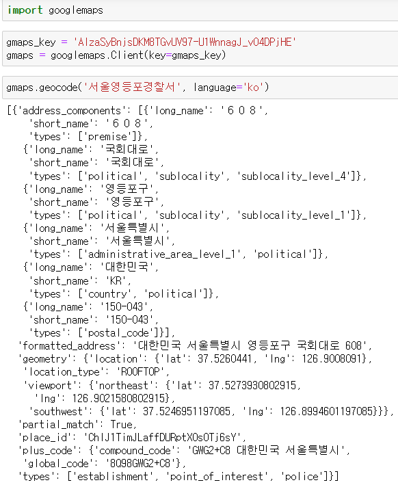
- Google Maps API를 통한 데이터 추출
tmp[0].get('geometry')["location"] #geometry의 key에 해당하는 value 반환 후 location의 kiey에 해당하는 value 반환(dict type 이기에)

tmp[0].get('geometry').get("location") #dict.get('key') = dict['key']
print(tmp[0].get('geometry').get("location")['lat']) #위도 출력
print(tmp[0].get('geometry').get("location")['lng']) #경도 출력
tmp[0].get('formatted_address') # 전체 주소 출력
tmp[0].get('formatted_address').split() # 띄어쓰기 형태로 구분하여 list에 담아줌
tmp[0].get('formatted_address').split()[2] # 세번째 아이템 출력(경찰서가 위치한 구)
- 데이터 프레임에 구별, lat(위도), lng(경도) 컬럼 추가
crime_station["구별"] = np.nan
crime_station['lat'] = np.nan
crime_station["lng"] = np.nan
crime_station
- 경찰서가 위치한 구이름 얻기
- 구이름과 위도, 경도 정보를 저장할 준비
for idx, rows in crime_station.iterrows():
    print(idx)
    tmp[0].get('formatted_address')
- 반복문(iterrows)을 이용해서 위 표의 NaN 값을 채우기
count = 0
for idx, rows in crime_station.iterrows():
    if str(idx) != '종암' :
        station_name = '서울' + str(idx) + '경찰서'
        tmp = gmaps.geocode(station_name, language='ko')

        tmp_gu = tmp[0].get('formatted_address').split()[2]
        lat = tmp[0].get('geometry').get("location")['lat']
        lng = tmp[0].get('geometry').get("location")['lng']
        # 데이터 프레임의 NaN을 채워줄 data 확보

        crime_station.loc[idx, "lat"] = lat #loc 함수는 '인덱스명'으로 인수를 받음(iloc는 인덱스 번호)
        crime_station.loc[idx, "lng"] = lng
        crime_station.loc[idx, "구별"] = tmp_gu
    else :
        continue

    print(count)
count += 1- count는 반복문 작동 여부 확인용

- 인덱스 개수(경찰서 개수)만큼 숫자(count) 출력 완료 - 반복문 정상 작동
-
위치한 구, 위도, 경도가 추가된 데이터프레임

-
여러 레벨로 나뉘어진 컬럼명 확인
crime_station.columns.get_level_values(0) #0번째 행
- 컬럼 합치기
# 컬럼 합치기
tmp = [
    crime_station.columns.get_level_values(0)[n] + crime_station.columns.get_level_values(1)[n]
    for n in range(0, len(crime_station.columns.get_level_values(0)))
    ]
tmp # 새로 넣을 컬럼명
- 컬럼명 교체 및 결과 확인(이때 원본 컬럼 개수와 교체할 컬럼 개수 확인 필요(len함수 이용))
crime_station.columns = tmp
- 데이터 저장
crime_station.to_csv("../data/02. crime_in_Seoul_raw.csv", sep=',', encoding='utf-8')
개발도상인 냄비짱